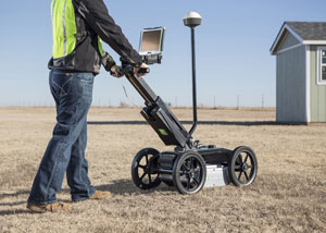
Easy GPS connectivity allows operators to see their path and marks in real-time as they scan, and the new wireless connection enables users to easily download web-based maps such as Google Earth.
The one-touch recalibration button lets operators transition from one scanning surface to another quickly and easily, while the earth-engaged antenna provides better contact on uneven terrain and reduces signal loss.
The 2550GR locates both metallic and non-metallic pipes and cables to allow one-pass locates at depths of up to 19.7 feet, depending on soil conditions and antenna selection. A 5.6 mph survey speed and digitally controlled radar allow the 2550GR to provide fast, clear images.
In addition to utility mapping efforts, the 2550GR’s advanced locating capability makes it ideal for a wide range of other applications including void and sinkhole detection, concrete detection, and locating underground storage tanks.